Americans treat their political map as though it were a geological feature — something that emerged from the landscape rather than from a series of contingent decisions made by people under pressure. State boundaries appear on every classroom wall with the authority of natural law. The shape of West Virginia looks inevitable. The straight lines dividing the western states seem like the only logical arrangement.
 Photo: West Virginia, via www.rent.com
None of it was inevitable. All of it was argued over, and most of it was nearly different. The history of American political geography is, at its core, a history of boundary disputes resolved by whoever had the most leverage at a given moment — and then promptly forgotten by everyone who inherited the result. When modern proposals to redraw state lines or reorganize regional governance are dismissed as radical fantasies, the dismissal rests on a historical amnesia that the record does not support.
Human psychology, including the psychology of territorial attachment, has not changed in five thousand years. The same drives that caused Roman provinces to fragment and consolidate, that moved medieval European kingdoms to absorb and expel territories across generations, operate in every American redistricting fight and every secessionist county movement. What follows are five episodes in which those drives reshaped the American map — and what each reveals about the mechanics of geographic reinvention.
One: The Dissolution of Dakota Territory (1889)
Dakota Territory was, for a quarter century, a single administrative unit covering what are now two states and portions of others. The proposal to divide it was not primarily geographic — the territory's northern and southern halves shared climate, economy, and settler demographics in roughly equal measure. The division was political.
Republican Party strategists in Washington recognized that a single large state would produce two senators. Two smaller states would produce four. The arithmetic was straightforward. In 1889, Congress admitted North Dakota and South Dakota simultaneously, along with Montana and Washington, in a deliberate act of political engineering designed to lock in a Senate majority. The boundary between the two Dakotas was drawn at the forty-sixth parallel for no reason more principled than convenience.
The residents of the territory were not universally enthusiastic. Many preferred a unified state. The southern portion, which had the larger population, understood that division would permanently dilute its influence. Their objections were noted and disregarded. The map was redrawn to serve the interests of people who did not live on it, a pattern that would recur.
Two: The Creation of West Virginia (1863)
No episode in American geographic history is more instructive about the plasticity of political boundaries than the creation of West Virginia. The western counties of Virginia had long chafed under governance from Richmond, whose political economy was organized around plantation agriculture that the mountainous west could not and did not share. When Virginia seceded in 1861, the western counties held their own conventions, voted to remain in the Union, and petitioned Congress for statehood.
The constitutional question was remarkable. Article IV of the Constitution requires a state legislature's consent before its territory can be divided. Virginia had, in the Union's view, forfeited its standing by seceding — but the new West Virginia government was itself composed of delegates claiming to represent the legitimate Virginia legislature. The consent was, in effect, Virginia consenting to its own partition through a government the rest of Virginia did not recognize.
Lincoln signed the statehood bill after receiving a legal opinion he described, with unusual candor, as reaching the conclusion he had already decided was necessary. The boundary was drawn, and it has remained ever since — though the economic logic that produced it has never fully resolved. West Virginia's persistent poverty reflects, in part, the difficulty of building a viable state economy from terrain that was separated from its natural commercial connections precisely because those connections ran through the wrong political territory.
Three: The Oklahoma Land Runs and the Invention of a State (1889–1907)
Oklahoma's political geography was not designed. It accumulated. The territory was assembled from Indian lands ceded under duress, from the Unassigned Lands opened by the 1889 land run, from the Cherokee Outlet, and from the separate Indian Territory that existed alongside Oklahoma Territory as a distinct administrative unit. For nearly two decades, these regions operated under different legal frameworks, different court systems, and different relationships with the federal government.
When statehood arrived in 1907, the merger of Oklahoma Territory and Indian Territory into a single state was not the obvious outcome. The Five Civilized Tribes had actively lobbied for a separate Indian state — to be called Sequoyah — with its own constitution, which they had already drafted. The Sequoyah Convention of 1905 produced a governing document and sent delegates to Washington. Congress declined to act on it.
The decision to create one state rather than two was again a matter of political arithmetic, combined with a federal reluctance to create a state with a majority Native American population that might govern itself with genuine autonomy. The map that resulted was not a reflection of the people living on it. It was a reflection of the preferences of people governing from a distance — a circumstance with deep roots in the history of political cartography.
Four: The Postwar Proposals to Reorganize Appalachia (1960s)
In the years following World War II, as the coal economy collapsed and out-migration hollowed out the Appalachian interior, a serious body of policy thought emerged around the idea that the region's problems were partly geographic — that the existing state boundaries cut across natural economic and cultural units in ways that made coherent regional development impossible.
The Appalachian Regional Commission, established in 1965, was in part a response to this analysis. But more radical proposals circulated in policy circles throughout the decade. Some planners argued for the creation of a unified Appalachian development authority that would effectively supersede state boundaries for economic planning purposes. Others proposed formal interstate compacts that would give the region a single political voice in Congress rather than fragmenting its representation across thirteen states with competing interests.
None of these proposals succeeded in their most ambitious forms. State governments were unwilling to cede authority, and the political coalition required to redraw even administrative boundaries proved impossible to assemble. But the debate itself is instructive: within living memory, credentialed policy thinkers were seriously proposing to reorganize a substantial portion of the American interior because the existing lines had stopped producing functional governance. The map was explicitly understood as a variable, not a constant.
Five: The Jefferson State Movement and the Persistence of Partition Sentiment (1941–Present)
In September 1941, the citizens of several northern California and southern Oregon counties declared the creation of the State of Jefferson, appointed a governor, and began stopping traffic on US Highway 99 to distribute proclamations. The movement cited the same grievances that have animated every American partition effort: a remote state capital unresponsive to local conditions, an economy organized around extraction that sent its wealth elsewhere, and a political system that aggregated rural votes into irrelevance.
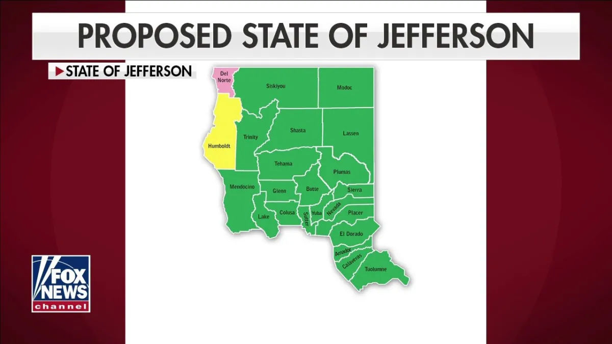 Photo: State of Jefferson, via cf-images.us-east-1.prod.boltdns.net
The declaration was overtaken by Pearl Harbor two months later, and the State of Jefferson retreated into regional mythology. But the underlying conditions did not resolve. The Jefferson movement has revived repeatedly — in the 1970s, in the 1990s, and again in the 2010s, each revival attracting enough signatures and county resolutions to demonstrate that the sentiment is durable even when the political path is not.
Jefferson is useful precisely because it never succeeded. It reveals the partition impulse in its pure form, uncomplicated by the compromises that actual boundary changes require. The same psychology that produced North Dakota and South Dakota, that created West Virginia, that assembled Oklahoma from incompatible pieces, continues to operate in the counties along the California-Oregon border. The lines feel permanent to everyone except the people living on the wrong side of them.
The Permanent Argument
What these five episodes share is not geography but psychology. In each case, people whose economic or political circumstances had changed found that the boundaries governing their lives had been drawn for a different set of circumstances and by people with different interests. In each case, the response was to contest the map itself.
The historical record offers no evidence that this impulse has ever been extinguished. It is suppressed, redirected, and occasionally satisfied, but it does not disappear. The Americans who dismiss contemporary boundary disputes as fringe politics are reading a map drawn by people who were themselves accused of fringe politics. The lines were always temporary. Only the argument feels new.